Castle Pines Village
Parks, Trails and Open Space Douglas County
Pinery Park, Whispering Pines Park, and Dupont Park
Pinery Park Ten acres at 8176 Hillcrest in the Pinery subdivision. Facilities include an unlighted playing field, a soccer field, two volleyball courts, picnic shelter, playground, and restrooms.
Whispering Pines Park Eight acres at 8000 East Park Drive in Whispering Pines subdivision, about one mile north of Franktown on the east side of Colorado 83. Facilities include an unlighted playing field, picnic shelter, playground, volleyball court and restrooms.
Dupont Park Eight acres in Louviers. Facilities include a lighted softball field, children's play area, picnic shelter and restrooms.
Regional parks: Castle Rock Regional Park, Highlands Heritage
Castle Rock Regional Park
Thirty acres at 701 South Gilbert Street, Castle Rock. Facilities include fitness area, two lighted softball fields, one soccer field, picnic shelter, playground and restrooms.
Highlands Heritage Regional Park
Located at South University Boulevard and South Quebec Street in Highlands Ranch. This 92 acre facility has 12 non-lighted multi-purpose soccer/football/baseball fields, open space, group shelter, playground, driving range and 18 hole miniature golf, and restrooms. A future amphitheater is planned.
Challenger Regional Park
Sixty acres in Parker, near Lincoln Avenue and Jordan Road. The park offers three lighted/irrigated ball fields, a huge children's playground, a restroom/scorekeeper building and lighted, paved parking.
State Parks and Recreation Areas
Castlewood Canyon State Park
The park occupies a secluded area about six miles east/southeast of Castle Rock, near the junction of Colorado 83 and Colorado 86 at Franktown. The main entrance is five miles south of Franktown on Colorado 83. Situated in a picturesque canyon, and home to the ruins of historic Castlewood Canyon Dam, the park features a new visitor's center, picnic areas, wildlife walks, and 13 miles of hiking trails. A large group picnic facility can be reserved. Environmental educational programs are offered, along with exhibits explaining the dam, area ecosystems and the Black Forest. The park has excellent access for the disabled.
Directions - Take Colorado Highway 83 south approximately 5 miles past the intersection with Colorado Highway 86. The entrance is on the right (west).
Chatfield State Park
On the South Platte River in northwestern Douglas County, this water-based recreation area encompasses 5,600 acres of land and a large reservoir. Recreational opportunities include power boating, sailing, waterskiing, swimming, fishing, picnicking, horseback riding, overnight camping, a model airplane field, a wildlife pavilion and a newly created 20 acre wetland and handicap fishing area. There is an 18 mile multi-use trail system that winds through the park. Most facilities are handicapped-accessible.
Directions - Access is from Denver south on Wadsworth Blvd to Colorado Highway 121 south, then east into the Deer Creek entrance.
Alternate access is south on Sante Fe Blvd to Titan Road, then north to the Plum Creek entrance.
Chatfield State Park
11500 North Roxborough Park Road, Littleton, CO 80125
(303) 791-7275
(303) 791-7547 (Chatfield Marina)
(303) 978-9898 (Chatfield Livery)
chatfld@csn.net (email)
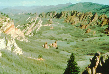
Roxborough State Park
The park features plant and animal life so diverse it has been declared a national natural landmark and archaeological district; consequently, pets, horses, and mountain bikes are not allowed. The park protects a series of sandstone ridges, the spectacular Fountain Formation, the Lyons Formation, and the Dakota Hogback in an area unique for its geology and mixture of plains and mountain habitat.
The park has a 12 mile trail system. A visitor's center is open year-round and outdoor educational programs are available.
Directions - The park is located southwest of Chatfield State Park at the edge of Rampart Range. From Denver, take U.S. 85 (Sante Fe Drive) south to Titan Road, turn right and go 3.5 miles. Follow Titan Road left for 3.0 miles. Turn left into the park entrance.
Roxborough State Park
4751 North Roxborough Dr
Littleton, CO 80125
(303) 973-3959 (phone)
rox@csn.net (email)
Pike National Forest
Pike National Forest is accessible by Colorado 67 west of Sedalia in Rampart Range. Camping, fishing, backpacking, and limited hunting
are available. Permits are required for certain activities. For information call (303) 275-5610.
Related Web Sites
Douglas County Park Info
Castlewood Canyon State Park
Chatfield State Park
Roxborough State Park
Pike National Forest
Colorado State Parks
Colorado River Watch
Colorado Division of Wildlife
Posted
by candy on 08/23/2001

- Advertise Here!
-
Promote Your Business or Product for $10/mo

For just $10/mo you can promote your business or product directly to nearby residents. Buy 12 months and save 50%!
