Northwest Neighborhood Association
Neighborhood History and Info
This is a work in progress. We welcome your input!
NWNA Boundaries
South: East Lee Street (north side)
East: North 1 st Avenue (west side)
North: East Seneca Street (south side), then north on 4th Avenue to Sahuaro Street (both sides)
West: North 6th Avenue (east side)
Social and Cultural Landscape
The NWNA along with two other Tucson neighborhoods were the de facto segregated neighborhoods for African Americans to live and buy or rent homes until federal laws and more accepting social standards encouraged equal opportunity where anyone could live and buy or rent homes. Today, there is a high percentage of African American population in the NWNA in comparison to the population of the metropolitan Tucson area. Many of these African Americans are long-time homeowners in today's NWNA. Part of NWNA and all of El Cortez Heights were and are sometimes referred still as Sugar Hill.
Northwest Neighborhood Statistical Information
Based upon 2000 census data made available by the City of Tucson, Department of Urban Planning and Design.
Housing units
- 394 housing units
- 189 (47.97%) are renter occupied
- 190 (52.03%) are owner occupied
Residents
- 966 (100%) residents
Demographic Information
- 308 (31.88%) Caucasian
- 258 (26.71 %) African American
- 16 (1.66%) Native American
- 64 (6.63%) Asian
- 510 (52.80%) Males
- 456 (47.20%) Females
- About 100 (20%) are below poverty level
- About 396 (41%) are under age 25
According to the 2000 Neighborhood Stress Index, compiled by the City, Department of Transportation, the NWNA has medium stress, same as the Sam Hughes Neighborhood Association area. A visual visit to both areas quickly demonstrates that the 'medium' designator encompasses a wide range of considerations and attributes. The NWNA is lacking in much of the infrastructure, physical and community, that one will see in Sam Hughes. Income levels are different. The types of housing and degree of maintenance are not similar.
Historical Landscape
 |
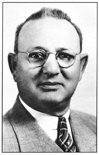
| Monte Mansfield |
What is now platted as the Schumacher Addition in March 1908 (SW corner of NWNA), and as Tucson Heights in 1904. The latter was registered with the County Recorder in April 1905. By September 1946, Monte Mansfield, known as Mr. Tucson, replatted the north portion of Tucson Heights and renamed it as the Mansfield Heights. In January 1950 The Maxwell family replatted Block no. 22 in Tucson Heights, and the block was renamed as the Maxwell Subdivision.
Today, the southern portions of the Schumacher Addition and Tucson Heights (Drachman Street to Lee Street) are part of the Feldman's Neighborhood Association, and the NWNA includes the Mansfield Park. There is a mix of housing styles from each decade from the 1920's to the present throughout the NWNA. Many homes seem to be from the 1950's, 1960's, 1970's, and 1980's, and a few from the 1990's based upon architectural styles and structural details. The various multi-unit apartment buildings, mostly along the eastern and southern portions of the NWNA, appear to be from the early 1980's and later. On the north side of Sahuaro Street there are 20 four- or five bedrooms dorm-dwellings, called Sahuaro Point Villas at the Park, owned and managed by QuatroVest Inc. QuatroVest Inc has been willing to work with EI Cortez Neighborhood Association and the NWNA through the Mansfield Park Neighborhood Coalition. Development plans by Michael A Goodman for additional dorm-dwellings to be built, between Lee Street, Third Avenue, Elm Street and 4th Avenue, were stopped by the City Board of Adjustment during the late summer 2006. There is one dorm-dwelling at 509 E Lee Street owned and managed by MAG Exempt Trust Holdings Co LLC. MAG Exempt Trust Holdings Co LLC also owns the property at 505 E Lee Street. The structure at 505 E Lee Street was razed sometime in 2006. As of May 2007, a new mini-dorm was being constructed at 505 E Lee. The MAG Exempt Trust Holdings Co LLC or Goodman owns several other parcels within the NWNA including the mini-dorm complex in the Southwest corner of the Feldman's Neighborhood Association (North 4th Avenue, on both sides of Adams Street). Recently (as of 2007), Goodman was allowed by the City to continue construction on two mini-dorms, 417 E Lee Street, immediately east of the Mt. Olive Church of God in Christ. These two structures were under construction when the City Board of Adjustment stopped further activity until certain plans and other actions took place.
Since 1890, the Pima County Board of Supervisors (Supervisors) has had several opportunities to listen to and respond positively to the concerns and issues from the residents in and within the vicinity of present day NWNA. The Supervisors had a role within the NWNA in shaping the flow of horse-powered traffic and later mechanized traffic. In 1890, the Supervisors defined road number 180 (now, North First Avenue) from Drachman Street to the Rillito. In 1928, the Supervisors approved, upon a petition from the then residents, a change in the public right of way from 75-feet to 60-feet for Road no. 180 from Drachman Street to Ft Lowell Road. The Supervisors, upon other petitions from the residents, in 1940 and in 1950, extended and later abandoned the North 4th Avenue extension from Seneca Street to Luna Road (now Grant Road). (The present day North 4th Avenue extension, acquired by the City of Tucson (City) in 1955, is along a slightly different alignment than the 1940's North 4th Avenue extension.) In December 1948, the Supervisors acted upon another petition from the residents, extending North 6th Avenue from south of Flores Street to Luna Road (Grant Road).
The City went through four annexations processes to acquire the present-day NWNA. In November 1919, the Schumacher Addition was annexed (Ordinance no. 493). In March 1923, one block, no. 31, of Tucson Heights was annexed (Ordinance no. 540). In September 1938, at the urging of Monte Mansfield, the City annexed the rest of Tucson Heights and all of EI Cortez Heights (Ordinance no. 822). This did not include what are now Mansfield Park (north of the Seneca Street alignment) and the properties immediately west of EI Cortez Heights to what would be North 6th Avenue. The City annexed in March 1959 these properties (Ordinance no. 1895).
The NWNA has undergone boundary changes itself. It was registered as a neighborhood association in October 1996. The NWNA acquired its present boundaries (see section II. Northwest Neighborhood Information) in May 2005.
The Bronx Wash
 |
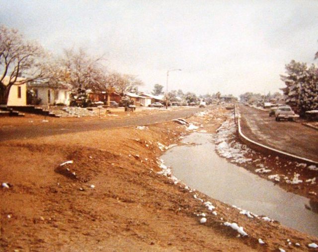
| The Bronx Wash before paving |
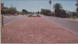
In a 1936 aerial photograph, the Bronx Wash is a natural (other than some dirt street crossings) vegetated watercourse with no houses or streets (Linden Street) along the wash. The dirt street pattern appears to indicate the area had been subdivided but not developed. A 1941 aerial photograph shows some development and the Bronx Wash is still a natural vegetated watercourse. After WWII, Tucson and Pima County underwent rapid expansion. In 1946, Linden Street (then called Hearst Street) was paved as a divided roadway (plan 1-457) on either side of the wash. It was again paved, and the wash was concrete lined and put into a culvert under North 6th Avenue in 1986 (Plan 1-87-13).
 |
| The Bronx Wash after paving |
The Pima County Regional Flood Control District (District) does not have much information on the Bronx Wash. Thewatercourse was constructed many years before the District was established. The Bronx Wash lies well within the City limits. For watercourses inside other jurisdictions the District has additional information on those drainage channels it maintains via Intergovernmental Agreements (IGA's). The District does not have an IGA with the City on this wash. Given the age of the city around the Bronx Wash [1938 annexation], there may be additional information with the Arizona Historical Society.
History of Infrastructure Improvements within NWNA and Immediate Vicinity
The NWNA was the recipient of paving and sewer improvements in two different phases. The Mansfield Heights, northern NWNA, was improved starting in September 1946. The rest of NWNA, the southern portion, was improved starting in April 1950. The Bronx Wash underwent human-induced changes during the paving and sewer improvements and again in 1986. North 6th Avenue, Speedway Boulevard to Grant Road, underwent a new paving improvement in 1986.
Sometime around the 1970's, Model Cities funded street lighting was installed in the eastern portion of NWNA. The City pays the monthly electricity bills for the Model Cities street lighting. Tucson Electric Power Company (TEP) street lighting was installed in the western portion and part of the eastern most portion of the NWNA. TEP street lighting is installed when a designated neighbor pays for the installment and the monthly electricity bill. It is City policy that it does not pay the monthly bills for these TEP street lights. It is not known when the TEP street lighting was installed. The City installed and pays the monthly electricity bill along North 6th Avenue (Speedway Boulevard to Grant Road) and along Seneca Street (1st to 4th Avenues).
In 1946 Monte Mansfield set aside a portion of Mansfield Heights and was "dedicated to the City of Tucson for park purposes." This land constitutes the southernmost portion of today's Mansfield Park, which has been known by that name since 1950 when the City established the park and named it after Monte Mansfield and his family. The City Parks and Recreation has always operated the park. The Land and Water Conservation grants provided a pool and bathhouse in 1967. A Mansfield Recreation Center was in the park. This recreation center was demolished in the 1990's. The Northwest Neighborhood Center, operated by the City Community Services, opened in 1978. Improvements, such as picnic facilities, ramadas, a soccer field, a playground and volleyball courts, were added in 1986, when the center's administration was transferred to City Parks and Recreation. The completion of a gymnasium and other recreational components in the summer of 2005 is fulfilling the goal of establishing a regional center in Ward III and is taking a giant step toward the rehabilitation of the Mansfield Park area.
Contact us: nwna85705@gmail.com


