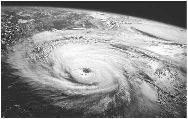
A hurricane is a type of tropical cyclone, the generic term for a low pressure system that generally forms in the tropics. A typical cyclone is accompanied by thunderstorms, and in the Northern Hemisphere, a counterclockwise circulation of winds near the earths surface.
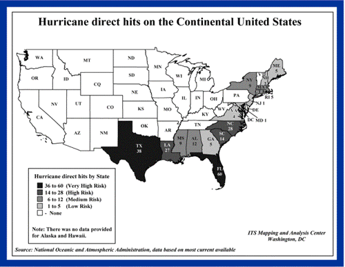
All Atlantic and Gulf of Mexico coastal areas are subject to hurricanes or tropical storms. Parts of the Southwest United States and the Pacific Coast experience heavy rains and floods each year from hurricanes spawned off Mexico. The Atlantic hurricane season lasts from June to November, with the peak season from mid-August to late October.
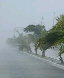
Hurricanes can cause catastrophic damage to coastlines and several hundred miles inland. Winds can exceed 155 miles per hour. Hurricanes and tropical storms can also spawn tornadoes and microbursts, create storm surges along the coast, and cause extensive damage from heavy rainfall.
Hurricanes are classified into five categories based on their wind speed, central pressure, and damage potential (see chart). Category Three and higher hurricanes are considered major hurricanes, though Categories One and Two are still extremely dangerous and warrant your full attention.
| Scale Number (Category) | Sustained Winds (MPH) | Damage | Storm Surge |
|---|---|---|---|
| 1 | 74-95 | Minimal: Unanchored mobile homes, vegetation and signs. | 4-5 feet |
| 2 | 96-110 | Moderate: All mobile homes, roofs, small crafts, flooding. | 6-8 feet |
| 3 | 111-130 | Extensive: Small buildings, low-lying roads cut off. | 9-12 feet |
| 4 | 131-155 | Extreme: Roofs destroyed, trees down, roads cut off, mobile homes destroyed. Beach homes flooded. | 13-18 feet |
| 5 | More than 155 | Catastrophic: Most buildings destroyed. Vegetation destroyed. Major roads cut off. Homes flooded. | Greater than 18 feet |
Hurricanes can produce widespread torrential rains. Floods are the deadly and destructive result. Slow moving storms and tropical storms moving into mountainous regions tend to produce especially heavy rain. Excessive rain can trigger landslides or mud slides, especially in mountainous regions. Flash flooding can occur due to intense rainfall. Flooding on rivers and streams may persist for several days or more after the storm.
Between 1970 and 1999, more people lost their lives from freshwater inland flooding associated with land falling tropical cyclones than from any other weather hazard related to tropical cyclones.

Naming the Hurricanes
Since 1953, Atlantic tropical storms have been named from lists originated by the National Hurricane Center and now maintained and updated by an international committee of the World Meteorological Organization. The lists featured only women's names until 1979. After that, men's and women's names were alternated. Six lists are used in rotation. Thus, the 2001 lists will be used again in 2007.
The only time there is a change in the list is if a storm is so deadly or costly that the continued use of the name would be inappropriate for reasons of sensitivity. When this occurs, the name is stricken from the list and another name is selected to replace it.
Sometimes names are changed. Lorenzo replaced Luis and Michelle replaced Marilyn. The complete lists can be found at www.nhc.noaa.gov under Storm Names.
Know the Terms
Familiarize yourself with these terms to help identify a hurricane hazard:
- Tropical Depression: An organized system of clouds and thunderstorms with a defined surface circulation and maximum sustained winds of 38 MPH (33 knots) or less. Sustained winds are defined as one-minute average wind measured at about 33 ft (10 meters) above the surface.
- Tropical Storm: An organized system of strong thunderstorms with a defined surface circulation and maximum sustained winds of 3973 MPH (3463 knots).
- Hurricane: An intense tropical weather system of strong thunderstorms with a well-defined surface circulation and maximum sustained winds of 74 MPH (64 knots) or higher.
- Storm Surge: A dome of water pushed onshore by hurricane and tropical storm winds. Storm surges can reach 25 feet high and be 501000 miles wide.
- Storm Tide: A combination of storm surge and the normal tide (i.e., a 15-foot storm surge combined with a 2-foot normal high tide over the mean sea level created a 17-foot storm tide).
- Hurricane/Tropical Storm Watch: Hurricane/tropical storm conditions are possible in the specified area, usually within 36 hours. Tune in to NOAA Weather Radio, commercial radio, or television for information.
- Hurricane/Tropical Storm Warning: Hurricane/tropical storm conditions are expected in the specified area, usually within 24 hours.
- Short Term Watches and Warnings: These warnings provide detailed information about specific hurricane threats, such as flash floods and tornadoes.

Take Protective Measures
Before a Hurricane
To prepare for a hurricane, you should take the following measures:
- Make plans to secure your property. Permanent storm shutters offer the best protection for windows. A second option is to board up windows with 5/8 marine plywood, cut to fit and ready to install. Tape does not prevent windows from breaking.
- Install straps or additional clips to securely fasten your roof to the frame structure. This will reduce roof damage.
- Be sure trees and shrubs around your home are well trimmed.
- Clear loose and clogged rain gutters and downspouts.
- Determine how and where to secure your boat.
- Consider building a safe room.
During a Hurricane
If a hurricane is likely in your area, you should:
- Listen to the radio or TV for information.
- Secure your home, close storm shutters, and secure outdoor objects or bring them indoors.
- Turn off utilities if instructed to do so. Otherwise, turn the refrigerator thermostat to its coldest setting and keep its doors closed.
- Turn off propane tanks. Avoid using the phone, except for serious emergencies.
- Moor your boat if time permits.
- Ensure a supply of water for sanitary purposes such as cleaning and flushing toilets. Fill the bathtub and other large containers with water.
You should evacuate under the following conditions:
- If you are directed by local authorities to do so. Be sure to follow their instructions.
- If you live in a mobile home or temporary structure such shelters are particularly hazardous during hurricanes no matter how well fastened to the ground.
- If you live in a high-rise building, hurricane winds are stronger at higher elevations.
- If you live on the coast, on a floodplain, near a river, or on an inland waterway.
- If you feel you are in danger.
If you are unable to evacuate, go to your wind-safe room. If you do not have one, follow these guidelines:
- Stay indoors during the hurricane and away from windows and glass doors.
- Close all interior doors, secure and brace external doors.
- Keep curtains and blinds closed. Do not be fooled if there is a lull; it could be the eye of the storm - winds will pick up again.
- Take refuge in a small interior room, closet, or hallway on the lowest level.
- Lie on the floor under a table or another sturdy object.
Other Hurricane Related Articles:
 Print
Print Email
Email


